
The San Pedro River Valley
Current Prospects For Destruction Of An Ecosystem
This website addresses the issue of the Arizona Department of Transportation's proposal to construct an I-10 Bypass through the San Pedro River Valley. Our argument is presented in two sections: first, a summary listing of our major points as prepared to be presented at the ADOT Board meeting of December 21, 2007, and second, an extended presentation of our original arguments against the proposal, placed on the website in July of 2007 when additional San Pedro Alternatives were being proposed. Section One provides the basic case in brief; Section Two will give concerned readers much additional informative detail on various parts of the valley should they want to look more closely.
...................................................
Section One
Major Points For The ADOT Board To Consider
December 21, 2007
"All forms of life modify their contexts, but no creature other than man has ever managed to foul its nest in such short order." (Lynn White, Jr.)
(1) While any ADOT Bypass for I-10 would seriously (and unnecessarily) damage and undermine precious lands and life-forms, the routes proposed for the San Pedro River Valley (including that for its Aravaipa tributary) would assault a valley that is both biologically rich and relatively constricted in width. Construction would have to occur in or very near the floodplain, and would entail huge expenses of construction and maintenance and enormous, certainly irrevocable damage to unique environmental and conservation interests.

(2) We have clear historical evidence for this outcome right within the San Pedro Valley: during the 1970s, a large roadway project similar to todays route designated "K-2" in the ADOT plan (though much smaller in scale than this one), was actually begun by the ADOT, aiming to run through the entire Middle San Pedro from I-10 in the south to San Manuel in the north, in order to serve then-current mining interests. It was abandoned due to inability to resolve major drainage problems and excessive taxpayer expenses had been incurred, after just 2 large bridges and associated hill cuts (see two images of one bridge complex below), covering less than one mile of the more than 30 miles required to complete the task. (Images below, Cascabel Road, between Mileposts 4 and 5)


(3) Now, in this new day of much greater national and global awareness of dangerous limits on fossil fuel, water, and species diversity resources, the 21st-century edition of ADOT, instead of learning from this previous mistake, proposes a much larger scale, much more ecologically damaging prospect for the same area starting a few miles further north. In the map below see route K-2. Apparently the alternative with which the ADOT is currently most engaged, K-2 would run from Willcox into the valley near Milepost 15, thence through Cascabel northward to San Manuel and beyond. (map adapted from TOPO! program)

(4) Precisely in the area where the ADOT K-2 Alternative would enter the heart of this ecosystem from the east and south, the valley narrows like a funnel into a long, side-constricted channel where Interstate-type road construction must cut right through the floodplain or its immediately-adjacent uplands. Here, as side-ridges descend close to the river, the number, frequency, and complexity of cross-cutting wildlife corridors multiplies, as would the range of radiating economic, ecological, and humanistic costs that would result from massive road construction. (Below, beartracks photographed in Sierra Blanca Canyon in September of 2004 reflect the intensive use of these corridors as these animals cross between the Galiuros and Winchesters to the east and the Catalinas and Rincons to the west in their search for "greener pastures".)

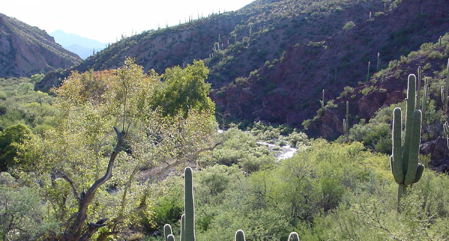
The wildlife corridors that must be considered include not only such major ones as those labeled above -- Kelsey Canyon, Teran Wash, Sierra Blanca Canyon, and Paige Canyon -- but also smaller, less conspicuous ones -- Pool and Palomas Washes, and others even smaller: all such corridors are significant for wildlife here and would have to be respected to preserve ecosystem integrity. Many bridges would be required to handle the direct problems of drainage alone. (Below: the river's gallery forest near Milepost 16 in December 2007.)

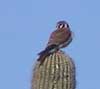
(Below, a Ferruginous Hawk, a recurrent seasonal visitor near Cascabel Road M.P.19, photographed in November of 2007.)

Below: a stretch of permanent river near Milepost 14 in April 2005. While this location is upstream from the K-2 Alternative's entrance into the valley, permanent water emerges and submerges at various points along this portion of the river, and richness of wildlife pervades all along. Coyote Willow trees, favorite habitat for the endangered Southwestern Willow Flycatcher, grow along this stretch of the river. Such upstream resources would of course be impacted by massive destructions further down.

(5) At the heart of the San Pedro's geographical constriction lies the Cascabel central corridor complex, which meets every criterion of desert ecosystem indispensibility, forming a veritable star of intersecting, permanent-stream-connecting wildlife corridors, providing the Galiuro, Santa Catalina, Rincon, and Winchester Mountains with pathways for intra-species communication. (aerial photo thanks to Google Earth)

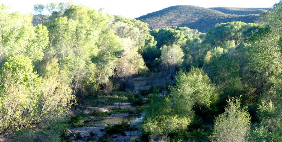
Hot Springs Canyon is an ecological treasure, with a permanent stream, several species of native fish, a wide variety of resident plants and animals. (Below: upper Hot Springs Canyon in November 2002)
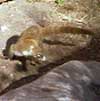
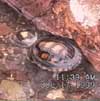
Among the other animals in which this corridor Core is especially rich are our mountain lions (as well as other carnivores -- bears, coatimundis, wildcats, ringtails, coyotes, foxes, badgers, et al). Mountain lions are the key predators in this biome, big cats in particular marking a key sign of a healthy ecosystem, the "apex predators" therein, who reflect and sustain the condition of the other animals down the food chain. The fact that the Cascabel corridor is well populated with them indicates the importance of this geographical "star" that interconnects the sky islands around it, a value that should warrant a "protected" designation for this priceless location. (Below: animals photographed nocturnally here with an automatic infrared camera.)
 .
. .
.
 .
.
Moreover, Hot Springs Canyon is an unpredictable, dynamic (and on occasion quite dangerous) water-and-debris carrier, which sometimes displays highly destructive power. For safety, it would require very substantial (and expensive) bridges to cross it, whether in the floodplain or on the adjacent very rugged uplands. On the other side of the constriction, Paige Canyon can (and just a few years back, did) dump a temporary dike across the entire river floodplain, causing the San Pedro River to back up for days until rising floodwaters cut through the dike. You can still see the white-sands residue of this event on the aerial image above. A great many very large concrete pillars would be required to build a multi-lane highway all along this central corridor core.
(6) Interstate Highway construction in the vicinity of Soza Mesa (or its counterparts on the western side) would be both builders and maintainers nightmares, repeatedly facing the closest geo-hydrological metaphor of the volcanic Lahar -- that is, debris floods churning massive loads of rock and trees in with (and thickening) the onrushing water. (Below, upper Jack Murphy Wash in the aftermath of January 2004 floods. The San Pedro floodplain is marked by a pale light horizontal strip, lying below and out of view at upper-middle left. A heavy debris deposit arrived there.)

Any suggestion to build a roadway across any part of this at once dangerous and life-forms-sustaining tableland seems preposterous: multiple bridgings, a floodplain freeway on high, massive stilts, in effect drastically degrading the quality of lives across and along the river. Not only of Soza Mesa but all its counterparts along the river, forms unique, highly rich and inconspicuous nursery places for impressive varieties of plants and animals. Below, the rich (and today, increasingly uncommon) Bush Muhly grass found in Soza Mesa's many valley "fingers", and some of that grass's most eager local consumers)
 .
.
At Milepost 31, the San Pedro River rises again as perennial stream, rich in fish, migratory fowl, the suites of creatures who rely on such zones. The Redington Narrows forms a tight bottleneck that can back up debris-laden waters during heavy floods, which would seem to preclude roadways in the floodplain here. The adjacent uplands remain rugged and would be expensive to cross with a big highway.

(7) The Redington area links important natural corridors, one traversing a Nature Preserve and the other extending into imposing federally-designated Wilderness. (image below of Redfield Canyon is from March 2004)


At this point the valley widens sufficiently that building a Bypass would probably not be quite so expensive as (and perhaps slightly less ecologically damaging than) would obtain in the corridors a short distance upstream, but the very fact that Redington has more flat (much of it private) land means that an off-ramp nexus would surely be designated here, followed by widespread eco-destructive urbanization. The now-primitive linking uplands of Redington Pass would soon be paved, and the vital ecosystem once symbolized by the Bellota Ranch would be ruined.
(8) Summary Judgements and Recommendations:
The San Pedro Valley is not only special to us, but to the people of the state and the nation. As such, many government agencies, at the city, county, state, and federal level, have invested heavily in maintaining the ecological integrity of the valley. The proposed bypass would heavily damage the fruits of these efforts and subsequent associated developments would destroy them. In addition, -- and this is a major point we have not previously made here some of the investments in conservation have been made as part of formal mitigation arrangements to compensate for the loss of riparian habitat associated with water developments in other parts of the state. The proposed bypass would contribute to hydrologic dysfunction in the watershed, and associated developments would lead to the depletion of the aquifer that feeds the San Pedro. The proposed I-10 bypass, if built, would nullify the benefits of the mitigation purchases by destroying the context in which they were made. The result would be a cascade of complications statewide.
Regionally, southeastern Arizona from I-10 to the Gila River represents a landscape not yet fragmented by development. a key national scale migration corridor south to north, and also a key way station in migrations east/west between sky islands. The destruction of the east-west cross river movement of wildlife cannot be mitigated by a few large bridges because of the multitude of smaller washes and tributaries that are biologically important. The health of the river depends on the health of the watershed that supports it and conversely the health of the watershed depends on the health of the river because of the self-regulating interaction of the wildlife populations. The proposed by-pass would disrupt these connections with regional consequences.
Globally, the Arizona Department of Transportation cannot ignore that well within the lifetime of the proposed bypass, fossil fuel shortages will be chronic, the price of fuel will be high, and global warming will continue to be an international concern. This is the context in which the proposal is being made. To say no to the I-10 bypass is to say no to the fossil-fuel dependent, global warming policies of the Twentieth Century, and to say yes to planning for an alternative, more sustainable Twenty-first Century. The ADOT I10 Bypass study is far too narrowly conceived. We need to look at how we in Arizona want to live in a future of limited oil and global warming and to discover what infra-structure best fits this future.

............................................
Section Two
Critique of the June 2007 Proposal for an I-10 Bypass Route through the San Pedro River Valley
Composed in June and July 2007
Early in 2007, The Arizona Department of Transportation (ADOT) announced its study of the feasibility of an interstate bypass that would allow trucks and other regional traffic to avoid the Phoenix and Tucson metropolitan areas (see I-10 Phoenix/Tucson Bypass Study). A prime prospect for the bypass route is one that would connect to I-10 on the south side near Willcox, Arizona, run west and then northward through the San Pedro River Valley, and reconnect to I-10 north of Tucson and west of Phoenix.
The San Pedro River Valley is an ecological treasure. The riparian zone in the valley bottom is rich and rare; tributaries that join the river from the sides are crucial wildlife corridors between sky islands; and the bajadas above the river bottom span an important transition zone from Apache Highlands to Sonoran Desert Uplands. Investing many billions of dollars in an interstate bypass through these lands would be an environmental disaster. Please lend your attention to our concerns.
Here below see the map indicating the various alternatives ADOT claims to be actively considering.

While the study Planners claim that all the color-marked alternatives are being weighed with equal objectivity, it is noteworthy that no fewer than 5 of them -- "A", "B", "J", "D", and "K" -- converge to run along the San Pedro River, the largest undammed river in the entire American southwest (see Biological Diversity Factsheet). If constructed, these routes would strike into a wilderness heartland which the Nature conservency has designated "one of the last great places". This river corridor is frequented by nearly half of all North American bird species, and supports the second highest number of mammal species in the world. See this link -- Recovery, Refuge, Homes -- for a very partial listing of the many different varieties of other animals (mammals, reptiles, fish, arthropods, etc.) who depend on this place. Here below are merely a few of the mammals who should have a "voice" in such decisions.


Human beings do also occupy this land, and nearly all of them who live there are horrified by the prospect. Let us, the organizers of this website, be clear: we oppose this idea with all our minds and hearts.
Side-page: authors of this website
We all agree that far more than economic interests must become decisive in this case: to be specific, very heavy burdens would be placed upon much wider human populations than the citizens of Tucson -- people living throughout our state, elsewhere in our nation, elsewhere in the world if this river-route roadway were to be built. Humans, animals, plants, other wildlives, and mineral and hydrological regimes would be adversely affected. An interstate highway bypass pushed through this ecologically sensitive area would have impacts far exceeding the short-term convenience of roadway commuters of Tucson.
Our discussion is organized with side-pages. Primary argument is presented in the main page, supporting information in the side-pages. For readers with limited time and/or distinct areal focus of interest, we suggest you read from top to bottom, then from side to side as wanted.
The San Pedro River
"The riparian ecosystem along the unregulated San Pedro River is one of the most valuable in the Southwest, particularly for birds. " Webb, Leake, & Turner 2007, p.223.


![]()
![]()
The San Pedro River begins in Mexico (in the Sierra Manzanal Mountains, not far from the city of Cananea in northern Sonora) and ends at its confluence with the Gila River near Winkelman, Arizona. For initial map orientation, see this link: San Pedro River Maps. The Nature Conservancy has designated the entire river and its watersheds (totaling some 1,370 square miles) as one of the earth's "Last Great Places".
Such a place deserves to be conserved, and our intention here is to enable everyone interested in it to see images and find more detailed descriptions of its history, its nature, its multiple distinct locales, and its potential futures. Our region has changed greatly over time, and we will make brief references to its geology as well as history, and to its now-reigning (as well as then-reigning) flora and fauna.
Major Divisions of the San Pedro
The Arizona Department of Water Resources (ADWR) and the United States Geological Service (USGS) now designate three distinct Watershed Areas for the river:
-- The Upper San Pedro (from its source in Mexico to the Tombstone Gaging Station, including the Sierra Vista Sub-Area),
-- The Middle San Pedro (including the Benson Sub-Area, from the Tombstone Station to the Narrows,and the Redington Sub-Area, from the Narrows to the Redington Bridge Gaging Station),
-- The Lower San Pedro (from Redington Bridge to the confluence with the Gila River.
While the entire river drainage would ultimately be adversely affected by running an Interstate Bypass along it, we here set aside both the Upper and the Lower Areas of the river (placing them in side-page appendages at the end of this report), and concentrate on the Middle San Pedro, where direct (and irreversible) damage would be done. Moreover, within that Area, we will concentrate on that part of the valley where it constricts north of the City of Benson. While we do not ignore the areas around Benson, we bracket them off into side-pages, both because we know those areas less than do long-time occupants there and because we argue that the most disastrous impacts would occur further north.
Our Arguments against any San Pedro River Valley Bypass:
(1) Compared with the valleys through which all the other Bypass Alternatives would run, those designated for the San Pedro would traverse a valley which is significantly more constricted and steeper. This means much greater expense of construction and maintenance and much greater damage to environmental and local human interests.
In the map below, we mark the approximate location of the city of Benson with an "X" (at lower middle), which is also the mid-section of the San Pedro River Valley and the point near which the ADOT alternatives we are most concerned about depart.

The prime geologically (and also transportationally) significant fact to be seen in this map is: compared with the Santa Cruz & Avra Valley complex to the west and the Sulphur Springs Valley and the Gila & San Simon Valley complex to the east, the San Pedro River Valley is significantly narrower in its structural form.
In the closeup map below, showing the Alternatives projected for the route north of Benson, the parts of Alternatives "D" and "K" lying north of Benson run through this constriction. These will be the focus of our examination.

Alternatives A, B, J, and the lower reaches of D and K lie outside both our intensive knowledge and our sense of immediate, serious impact. Therefore we will set aside the first three of these Alternatives for examination by others, and will relegate the near-Benson-area portions of D and K to side-pages in our own report. In the side-page immediately below, we seek to provide some relevant context for those who may want to pursue arguments concerning the Alternatives proposed there.
Side-page: The Middle San Pedro and Benson areas below the constriction
Approaching The Heart of the Middle San Pedro: Tres Alamos Wash

In the image above, the broad floodplain of Tres Alamos Wash runs from near lower-right to mid-left foreground, then bends sharply rightward against the high terrace which slants across the photo from above-mid-left to the upper center of our view. (This terrace formation dates from the time of the St. David Formation Lake of the Pliocene period). The constriction of the valley may be seen at this point, where the terrace on the east side of the river reaches down toward those on the west. At the far lower end of the terrace, you can see a short horizontal strip of pale green, marking irrigated farmlands and buildings located on the San Pedro River floodplain. (A Hohokam ruin is located near this confluence.) Across the valley, counterpart near-horizontal-appearing Pliocene terraces are visible, with the Little Rincon Mountains above them and Rincon Peak rising further behind. The bajadas there have remained part of the prehistoric Apache Highlands Grasslands. Just upstream from and out of view to the left of the Pliocene terrace formation at mid-left, Ash Creek runs into the San Pedro from its source in Happy Valley beneath Rincon Peak. These places are directly relevant in our prior discussion of Benson Sub-Area (particularly side-page Lower reaches of Alternative D).
ADOT Alternative D is planned for the west side of the river in the area just described.
These two converging washes point to a typical feature of the entire valley, which will be remarked from this location northward: essentially, the whole area is a criss-cross of wildlife corridors - routes by which plant and animal species may move from one "sky-island" mountain range and its foothills to another, thus maintaining numbers and genetic diversity. Topo maps we present below will illustrate only a few of these corridors, which are however multiple and connect both the Catalina and the Rincon Mountains on the west to both the Galiuro and the Winchester Mountains on the east. Many of these washes contain springs, permanent streams in their upper reaches, including populations of fish, and mountain lions and bears purposefully walk down some of these washes following pools of water on their way to the river and beyond. Population pressures in one area may stimulate species recoveries in another.
However, the ecological values of the area have not prevented developers from trying to drive "improvements" through it in the past:
(2) In the 1970s, an effort to construct a large roadway similar to Alternative K (though much smaller in scale) through the entire Middle San Pedro to highway I-10 was attempted by the ADOT as a way to facilitate special economic interests. It was abandoned only after major taxpayer expenses had been incurred, and the scale, cost, and environmental problems involved in the enterprise were belatedly recognized.
Side-page: The "Grand Roadway": A Previous, Aborted Version of Alternative K


"If I were asked for a prescription for where architects and planners should go to learn their trade, it would be this: Go out to nature and learn from experience what natural structures men find beautiful, because it is among those structures that men's aesthetic sensitivity evolved." [Nicholas Humphrey, architect and architecture teacher]
Journey to the Heart of the Middle San Pedro
Where Alternatives K and D Must Coalesce:

The Narrowing Funnel: Arguments and Evaluations

In this part of the river valley, many details of fact and evaluation arise, and we focus discussion by continuing to present distinctive arguments and evaluations summarily and briefly, numbering each of them, while relegating to the side-pages the details supporting each generalization. As readers may have noted, we color these statements green in defiant stereotype, to emphasize a contrast of our perspective with the color of a world covered by asphalt.
(3) Upland landforms and lifeforms near and north of the Grand Roadway cuts, part of the Chihuahuan Desert and Apache Highlands Ecoregions, are sustained by both the river and the corridors that crosscut it. In the floodplain, rare Fremont Cottonwood/Goodding Willow Gallery Forest supports large populations of birds and other wildlife. Either "D" or "K" routes would damage the integrity of this life-support system. (In the side-page below, pay particular attention to the life-sustaining qualities of the vicinity of the Three-Links Ranch.)
Side-page: Tres Alamos north through Three-links Ranch

(4) This Redington Sub-Area of the Middle San Pedro narrows like a funnel into a long, side-constricted valley where Interstate-type road construction must either cut through the floodplain and its immediate margins, or cut through the adjacent uplands on either side. Any of these alternatives are unacceptable, both for gross economic reasons and for the devastation of life-corridors they would create. Here, as the valley constricts, the number, frequency, and complexity of cross-cutting corridors begins to multiply, as would the range of radiating side-effects from massive road construction.
Side-page: Alternatives D & K at the Redington Funnel
(5) Near Kelsey Canyon crossing, and northward through the Teran Wash crossing, the valley constricts further, cross-cutting corridors become larger and adjacent uplands even closer, and the obvious economic/ecological/human costs would further multiply. Since the main feasible routes lie in or very close to the floodplain, serious issues of local access to a Cascabel Road route would arise. The prospects here become daunting to say the least. (See the side-page for more details.)

Side-page: the Narrowing Funnel from Kelsey Canyon to Sierra Blanca Canyon Wash
The Central Geo-ecological Constriction along the San Pedro River
Here we must set aside side-paging for the moment, and present the most essential details:
Point (6) argument will follow this presentation.
Paige Wash Meets Hot Springs Canyon
Below: Lower Hot Springs Canyon Wash and its mesquite bosque, running westward (lower left to middle-right) toward its confluence with the San Pedro in the middle distance: (July 2002)

Mesquite trees are very important in the historical ecology of this area.For more information on the importance of this tree both in the past and as an emergent food source today, click on mesquite.
Below: Confluence of Hot Springs Canyon Wash (foreground gallery forest) with the San Pedro River (the river's cut can be seen at right central) and Paige Wash (just visible beyond the left-central ridge terrace at dead center in the photo) -- Rincon Peak in the right background, Little Rincons dominate the mid-distance: (May 2002) Almost all of the greenery seen in the distance (except for the gallery forest along the cut of the river) is mesquite bosque. (Click on image below to enlarge.)

We are now viewing the Cascabel-Paige Wildlife Corridor. In the map below, Hot Springs Canyon enters this central point from far-upper right along the high terrace marked near the roadway by the indicated "landing strip".
This watershed has perennial streams in its upper reaches and is a major wildlife refuge for the region. (For initial visual details, see Hot Springs Canyon, and for much broader ecological detail see the entire Saguaro Juniper Corporation webpage.)

In the map above, Paige Canyon enters this constriction at bottom-center, hauling its water resources down from the perennial springs of the Happy Valley Basin in the Rincon and Little Rincon watershed. Roble Canyon joins the cluster running out of the Little Rincons from lower left, and it too has perennial springs. Pool Wash, running from the upper right corner to its confluence with the San Pedro just east of the Cascabel icon, is also a significant wildlife corridor, and the Sierra Blanca Canyon Wash, shown here at the right, also contains perennial springs. These corridors together form dynamic intersections of wildlife activity -- we have already emphasized the birds, and speaking personally we regularly observe bears, deer, javelina, coatimundis, and numerous other mammals crossing the webbed fingers of this crossroads (not to mention other non-mammalian forms like the sometimes seemingly ubiquitous Gila Monster, who definitely finds Cascabel to be a paradise).


Below, a view up lower Paige Wash from the San Pedro River terrace above the Community Center, looking a tad east of southward on February 22, 2008. In the lower left portion of the upper right quadrant of this image, Paige Creek Wash runs right-to-left through a gap between two Little Rincon peaks, then swings around toward the viewer to join the San Pedro River at a point roughly mid-picture (though largely out of sight here). The light-colored streak running across mid-picture on the right-hand side of the image is Cascabel Road.

Side-page: Roble & Paige Canyons
Another salient aspect of this vicinity derives from the fact that the slopes above the river mark an ecoregion boundary where different vegetation zones intermingle and enrich each other. While the more southerly portion of the valley uplands we have passed through is generally considered part of Apache Highlands and/or the Chihuahuan Desert, by the time we reach Cascabel the vegetation becomes more dominated by Sonoran Desert plants. (See that link) Below, a view of the north-facing slope of lower Hot Springs Canyon (taken from the opposite terrace in the early morning of January 2005: (Click on the image for a closer view.)

All of the obviously upright, sunrise-highlighted plants evident here on this slope are Saguaro Cacti, prime real actors among the distinctive plants of the Sonoran Desert. See The Arizona Uplands on the most characteristic features of our immediate area, and see Saguaros for details on the significance of this dominant plant in our ecosystem.
Below, a view of part of the above hillside taken in February 2008. Note the venerable age of many of these Saguaros. Somewhat surprisingly, across Hot Springs Canyon toward the south, the frequency of these trees declines quite sharply, and they nearly disappear beyond Kelsey Canyon.

(For a more extended [if somewhat out-of-date] discussion of Ecoregions, see Ecoregions in Our Area.) Thus the Cascabel locale has another quality of distinctiveness: as a multi-transitional zone, it intermingles life-forms from all three (or more) zones, and thus possesses an intensified diversity.
Side-page: Geology trip up Hot Springs Canyon

One might think that seeing these prospects would give serious pause to even the most ardent of imaginative southeastern Arizona Bypass-planners -- and then lend them the courage to discard this route, despite the intense occupational pressure likely to come from corporate entities heavily invested in road construction and trucking industries. Anyway, we hope so.
To address the obvious -- floodplain -- alternative here, consider where both the D and K alternative I-10 Bypass routes must pass through this priceless ecological central-point: they would have to drive their multiple-lane stakes right through one major beating heart of entire ecosystems. However much the Arizona governmental planners and their interstate, federal, and other corporate backers/inciters may protest their intention to create "clean" roadways, this Central Corridor of the Catalina Core Complex -to- Galiluro-Volcanics -to- Winchesters Wilderness would be destroyed as the living center it now is, much enjoyed by both people and wildlife.
But don't take our word (or the word of maps drawn by human hands) for it, regarding the centrality of this still-dirt-road-protected place. Witness the testimony of satellite Imagery (courtesy of Europa Technologies Inc. by way of Google Earth):
Dirt-Road Daddy-Long-legs Central Core

Even the lesser ridge/ravine dendrites you see here are not small. And more than damage to wildlife would be involved in building a highway through this Dirt-Road, Long-legs location. Some of these corridors also have explosive potentials to destroy (or at least overrun) human high-tech infrastructures, as will be seen below.


All along this portion of the valley, the volcanic fault-block-tilted escarpment of the Galiuro Mountains parallels the San Pedro Valley on its eastern side: (see that link for many more images and maps of this, the wildest mountain range in southeastern Arizona).

Its peaks rise high above the surrounding terrain (and have done so for a very long time, once much higher), and the fronts of the range are fairly close to the river at this point. Today, this intensifies runoff when monsoonal rains occur, and very massive flooding can result at many locations along this bottleneck corridor of the river.
Where the Cascabel Road crosses Hot Springs Canyon, below, the substantial rains of July 2006 produced a fairly strong stream flow photographed here by Susan Newman on July 29, looking southward. Although the roadway now has a belt of concrete surfacing that runs from side to side to stabilize the crossing at this very large wash, these vehicles are prudently waiting for the pulse to decline further. The strip of rocky alluvium sitting across the roadway shows that the previous flow was much stronger than what you see here. (Click on the image for a closer view.)
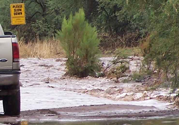
Think about an Interstate Freeway-prospect here: the bridge would have to extend well beyond the position of the photographer, far beyond and above the height of the vehicle seen waiting on the far side, and at three-to-four times the roadway width. Such a Highway would make unliveable Elna Otter's house and home (where Sunday Quaker Meetings are often held; the place is off to the left in the trees beyond the far parked vehicle), and we've not even mentioned residents on the downstream side of the wash at this point. For example, there are small but significant archaeological ruins, dwelling places of the O'0dham people of southern Arizona (whose ancestors lived here from pre-Columbian times until 1762) located near the present roadway. These ruins would surely be obliterated by any Highway construction along this road.
For visual and historical evidence of the power of Hot Springs Canyon Wash during flash-flood episodes, see these two side-pages:
Side-page: the Scouring Potentials of HSC Wash
Side-page: Death in Lower Hot Springs Canyon
To summarize for the Central Core so far, then:
(6) In terms of "Central-place" theory, Cascabel Central meets every criterion of indispensibility from a desert ecosystem point of view. It seems preposterous even to consider driving a stake through the dusty cephalothorax of this fixed-location, global-species-endangered eco-spider.
(7) Hot Springs Canyon is an unpredictable, dynamic -- and on occasion quite dangerous -- water-and-debris carrier, which sometimes displays highly destructive power. For safety, it would require very expensive and elaborate bridges to cross it, both in the floodplain (and to greatly magnified degree) in crossing the adjacent very rugged uplands. On the other side of the constriction, Paige Canyon can (and just a few years back, did) dump a temporary dike across the entire river floodplain, causing the San Pedro River to back up for days until rising floodwaters cut through the dike.
The Soza Mesa-Soza Canyon-Soza Wash Constriction

Just downsream and north of Hot Springs Canyon, a very large mesa looms high over the river floodplain (its long flat top visible in the image above). See its far-western naked shingles on this map:

Soza Mesa is a greatly elongated Pliocene terrace (7.5-5 Million years old, see Geology: more recent patterns), built by long-sustained erosion of the formerly much-higher Galiuro Mountains. Note how it forms "fingers" of descending slopes that fall down to the river. On this map it perhaps appears a somewhat bland structure, and it is not visually much evident from the roadway below, but in fact the levels shown here give little hint of its size. Its elevation at the top, where it forms a very extensive tableland, stands at 4200 feet at its highest northeast elevation near Wildcat Peak,and it remains almost tabletop-level for miles until reaching its western finger-edges at 4000 feet, then declines at somewhere near the angle of repose until it reaches the river at around 3000 feet elevation. The amount of eroding materials that descend to river (and roadway) during flood occasions can be (and often has been) huge. This has implications for roadway construction here.
(8) Interstate Highway construction in the vicinity of Soza Mesa (or its counterparts on the western side) would be both builders' and maintainers' nightmares, repeatedly facing the closest geohydrological metaphor of the volcanic Lahar -- that is, floods churning massive loads of rock and trees in with (and thickening) the water. And to speak ecologically only of Soza Mesa, it forms a unique and highly rich -- while very inconspicuous -- nesting place for impressive varieties of plants and animals. Any suggestion to build a roadway across any part of this at once dangerous and valuable tableland seems preposterous.
For details of Soza Mesa from a variety of perspectives, see these two side-pages:
Side-page: Soza Mesa and Interstate Bypass
Side-page: Mighty Soza Mesa
Some Short Shrift to Uplands Alternatives on either side of the River Here:
Below, a Google Earth satellite image looking from the north-northeast toward the three main washes running into the San Pedro from the western side (Paige Canyon, Roble Canyon, and Soza Canyon). (The whitish-colored deposits coming out of Paige Canyon at far left and running along the river all the way to the confluence with Roble Canyon are residue from the recent massive flood down Paige Wash mentioned in argument #7 above.) This viewpoint lies above Soza Mesa and shows hills running to the river from the west that are as deeply dessicated and rugged as those running down from Soza Mesa to the east.

The Google Earth image below, viewing the same area from the north-northwest, highlights the valley's constriction (on both sides of the river, but shows it here even more sharply on the west):

(9) the Satellite Photographs shown here, and the ecological/humanistic/economic objections to such alternatives we have already raised before reaching this juncture, would seem to render more formal argumentation unnecessary (In the uplands, multiple bridgings; in the floodplains, a freeway on high, massive stilts, in either case drastically degrading the quality of lives across and along the river.).
Lower Portions of the Redington Sub-Area:
Milepost 31 to the Redington Narrows
(10) At Milepost 31, the San Pedro River rises again as perennial stream, rich in fish, migratory fowl, the suites of creatures who rely on such zones. The Redington Narrows forms a tight bottleneck that can back up debris-laden waters during heavy floods, which would seem to preclude roadways in the floodplain here. The adjacent uplands remain rugged and would be expensive to cross with a big highway.
Side-page: Milepost 31 to the Redington Narrows
Redington: the Buehman-Redfield Corridor, and Redington Pass
(11) The Redington Core links important natural corridors, one traversing a Nature Preserve and the other extending into imposing federally-designated Wilderness. At this point the valley widens sufficiently that building a Bypass would probably not be quite so expensive as (and perhaps slightly less ecologically damaging than) would obtain in the corridors a short distance upstream, but the very fact that Redington has more flat (much of it private) land means that an off-ramp nexus would likely be designated here, followed by urbanization. The now-primitive linking uplands of Redington Pass would soon be paved, and the vital ecosystem once symbolized by the Bellotta Ranch would be ruined.
Side-page: Redington-Buehman-Redfield-Redington Pass
Points Further Downstream (to the North)

We will not presume to assess this area. For our brief consideration and assessment of the merger-point of "D" and "K" at the Pinal County line and further points northwestward, see this side-link:
Side-page: Lower San Pedro Area
Points Upstream toward the Mexican Border
We also decline to assess the Upper San Pedro in relation to the problems discussed here. For a brief consideration, see this side-link:
Side-page: Upper San Pedro Area
This concludes our formal detailed survey of locations we consider most vulnerable to great damage by those proposed I-10 Bypass Alternatives that would run the course of the San Pedro River, whether by uplands or along the river floodplain.
Summary Judgements and Recommendations
As you can see from the preceding presentation, the San Pedro Valley is not only special to us, but to the people of the state and the nation. As such, many government agencies, at the city, county, state, and federal level, have invested heavily in maintaining the ecological integrity of the valley. The proposed bypass would heavily damage the fruits of these efforts and subsequent associated developments would destroy them. In addition, -- and this is a major point we have not previously made here -- some of the investments in conservation have been made as part of formal mitigation arrangements to compensate for the loss of riparian habitat associated with water developments in other parts of the state. The proposed bypass would contribute to hydrologic dysfunction in the watershed, and associated developments would lead to the depletion of the aquifer that feeds the San Pedro. The proposed I-10 bypass, if built, would nullify the benefits of the mitigation purchases by destroying the context in which they were made. The result would be a cascade of complications statewide.
Regionally, southeastern Arizona from I-10 to the Gila River represents a landscape not yet fragmented by development. Not only is the San Pedro Valley a key national scale migration corridor south to north, but also it is a key way station in migrations east/west between sky islands. We have reviewed the geology of the region and described the patterns of tributaries to the San Pedro that are so crucial to the wildlife movement to and from the river in the cross river corridor. The section of the valley where it narrows, between Teran Wash and Redfield Canyon, is particularly vulnerable to such fragmentation with no way to build an interstate without serious damage. The destruction of the east-west cross river movement of wildlife cannot be mitigated by a few large bridges because of the multitude of smaller washes and tributaries that are biologically important. The health of the river depends on the health of the watershed that supports it and conversely the health of the watershed depends on the health of the river because of the self-regulating interaction of the wildlife populations. The proposed by-pass would disrupt these connections with regional consequences.
Globally, the Arizona Department of Transportation cannot ignore that well within the lifetime of the proposed bypass, fossil fuel shortages will be chronic and the price of fuel will be high. The EPA has declared that C02 can be regulated as a pollutant and that consequences of globally warming are already being felt and will accelerate. This is the context in which the proposal is being made. To say no to the I-10 bypass is to say no to the fossil-fuel dependent, global warming policies of the Twentieth Century, and to say yes to planning for an alternative, more sustainable Twenty-first Century. The ADOT I10 Bypass study is far too narrowly conceived. We need to look at how we in Arizona want to live in a future of limited oil and global warming and to discover what infra-structure best fits this future.
(Compare our Summary with The Cascabel Working Group Position Statement of June 2007, and the Report to ADOT by Daniel Baker Sep. 21, 2007.)
If you agree that we must spare the San Pedro Valley and seek a better future, feel free to use the talking points we have mustered here in discussions with decision-makers, friends, and family.
What we think about the viability of such a project may sometimes be better expressed in pictures rather than in words, as in this (perhaps subliminal) observation made by Mr. John Crossley (The American Southwest) on July 13, 1994, when -- stopping overnight to camp roadside while just passing through -- he had the wisdom to photograph this, the southern end of the Cascabel "Grand Roadway":
